


Boots and ALL my first walk!
Freycinet Peninsula
…Mt Dove
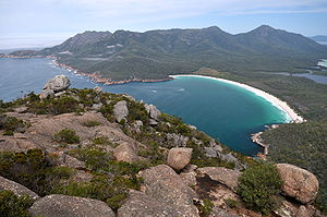
Sticking out into the sea on Tasmania’s mild east coast is the rugged and beautiful Freycinet Peninsula. Freycinet National Park consists of knuckles of granite mountains all but surrounded by azure bays and white sand beaches. The dramatic peaks of the Hazards welcome you as you enter the park. Freycinet is effectively two eroded blocks of granite – the Hazards and the Mt Graham/Mt Freycinet sections of the peninsula – joined by a sand isthmus.
Freycinet is a great place to go bird watching. You may be lucky enough to see a white-bellied sea-eagle gliding overhead or large Australasian gannet diving for food in the ocean.
Freycinet National Park offers a wide variety of activities. Take a walk to the pass overlooking the perfectly shaped Wineglass Bay, trek the entire length of the Freycinet Peninsula on an three day walk or try less strenuous activities like beach strolls, swimming or wildlife spotting.
Freycinet National Park
|
|
|
|---|---|
|
IUCN Category II (National Park)
|
|
|
|
|
|
Nearest town/city: |
Swansea |
|
Coordinates: |
42°07′31″S 148°17′54″E / 42.12528°S 148.29833°E-42.12528; 148.29833 |
|
Area: |
169 km² |
|
Established: |
1916 |
|
Visitation: |
200,000 [1] (in 2008) |
|
Managing authorities: |
Tasmania Parks and Wildlife Service |
|
Official site: |
Freycinet National Park |


Wineglass Bay and The Hazards from Mt Amos peak

The Hazards from the southern section of Hazard Beach
Freycinet is a national park on the east coast of Tasmania, Australia, 125 km northeast of Hobart. It occupies a large part of the Freycinet Peninsula, named after French navigator Louis de Freycinet, and Schouten Island. Bordering the national park is the small settlement of Coles Bay, and the largest close town is Swansea. Freycinet contains part of the rugged Tasmanian coastline and includes the secluded Wineglass Bay, voted by several travel authorities as one of the world’s ten best beaches. Famous features of the park include its red and pink granite formations and a series of jagged granite peaks in a line, called “The Hazards“. Founded in 1916, Freycinet is Tasmania’s oldest park, along with Mount Field National Park. Within the park Federal Hotels owns and operates Freycinet Lodge.
Flora
49 Tasmanian Endemic species are found at Freycinet.[2]
Fauna
Mammals found at Freycinet include the Brushtail Possum, Ringtail Possum, Sugar Glider, Eastern Pygmy Possum, Little Pygmy Possum, Echidna, Wombats, New Holland Mouse, Swamp rat, Water rat, Tasmanian Bettong and the Long-nosed Potoroo.[2] The Tasmanian Devil was once common at Freycinet, but has seen a significant drop in density due to the facial tumour disease.[2]
Geology
DevonianGranite is the dominant rock type at Freycinet.[2] Orthoclase, a pink feldspar gives the mountains and coastline their characteristic pink tint.[2] Black micas and white quartz are also found.[2] The western side of Schouten Island is composed of Jurassic Dolerite.[2]
Climate
The park receives on average 600 mm (23.6 in.) of rain per year. It has a climate similar to that of France with on average more than 300 days of sunshine.[3]
| Climate data for Friendly Beaches | |||||||||||||
|---|---|---|---|---|---|---|---|---|---|---|---|---|---|
| Month | Jan | Feb | Mar | Apr | May | Jun | Jul | Aug | Sep | Oct | Nov | Dec | Year |
| Record high °C (°F) | 36.4 (97.5) | 37.0 (98.6) | 37.0 (98.6) | 31.4 (88.5) | 24.0 (75.2) | 21.0 (69.8) | 19.0 (66.2) | 23.5 (74.3) | 27.0 (80.6) | 32.7 (90.9) | 35.0 (95) | 37.0 (98.6) | 37.0 (98.6) |
| Average high °C (°F) | 22.8 (73) | 22.6 (72.7) | 21.4 (70.5) | 18.6 (65.5) | 16.1 (61) | 14.1 (57.4) | 13.7 (56.7) | 14.7 (58.5) | 16.7 (62.1) | 18.0 (64.4) | 19.5 (67.1) | 21.8 (71.2) | 18.3 (64.9) |
| Average low °C (°F) | 13.1 (55.6) | 13.2 (55.8) | 11.8 (53.2) | 9.6 (49.3) | 8.3 (46.9) | 6.4 (43.5) | 5.7 (42.3) | 6.1 (43) | 7.5 (45.5) | 8.6 (47.5) | 10.0 (50) | 11.6 (52.9) | 9.3 (48.7) |
| Record low °C (°F) | 6.0 (42.8) | 7.2 (45) | 5.3 (41.5) | 1.0 (33.8) | -1.1 (30) | 0.0 (32) | -0.5 (31.1) | -0.1 (31.8) | 1.2 (34.2) | 1.2 (34.2) | 3.0 (37.4) | 5.5 (41.9) | -1.1 (30) |
| Precipitation mm (inches) | 61.2 (2.409) | 60.3 (2.374) | 53.7 (2.114) | 50.3 (1.98) | 47.0 (1.85) | 36.2 (1.425) | 48.5 (1.909) | 48.7 (1.917) | 33.3 (1.311) | 65.2 (2.567) | 58.8 (2.315) | 36.6 (1.441) | 601.7 (23.689) |
| Source: Bureau of Meteorology [4] | |||||||||||||
See also
- Protected areas of Tasmania
External links
| Wikimedia Commons has media related to: Freycinet National Park |
Coles Bay information website
References
- ^“Independent, tourism-related Web site for Tasmania”. Michael Lichon. https://tassie.org.au/freycinet/. Retrieved 2009-05-09.
- ^ a b c d e f g TASMAP – Freycinet National Park. DPIW.
- ^ Hema Maps (1997). Discover Australia’s National Parks. Milsons Point, New South Wales: Random House Australia. pp. 364. ISBN 1975992472.
- ^ “Climate Statistics for Friendly Beaches”. Australian Government. Bureau of Meteorology. https://www.bom.gov.au/climate/averages/tables/cw_092114_All.shtml. Retrieved 2 June 2009.

Freycinet Peninsula and Schouten Island seen from space (false color).

Wineglass Bay: Mount Freycinet (right) and Mount Graham (left) are visible behind
Nicholas Baudin named the peninsula after French explorer Louis de Freycinet. Baudin also named Cape Baudin, Cape Faure, Cape Forestier and Thouin Bay, although that Bay is now known as Wineglass Bay.[1] Source ~ From Wikipedia, the free encyclopedia

Quote:
“The indispensable first step to getting the things you want out of life is this: Decide what you want!” ~ Ben Stein